
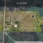
I flew the Mavic Mini around the property at 400 feet (~129 meters). At Belize international Airport I had WiFi and was able to upload the images from my laptop to Drone Deploy’s cloud-based software which processed 486 photos to make an orthomosaic map and 3D model. Here is a screenshot from my phone. The high resolution map and model are … [Read more...] about Aerial photomap of Belize Open Source
Base Camp Belize
Leaving Gamboa, Panama
I’m was at Canopy B&B, waiting for ride to airport. Now I’m in line at the airport. I had great time here. I came to visit Andrew Quitmeyer, at Digital Naturalism Laboratories (DINA: https://www.dinacon.org) via invitation from Shannon Dosemagen, long-time Public Lab friend. You can see what Public Lab is about at: https://publiclab.org/ I’d been intrigued by a map and 3-D model of Gamboa that Andy had made from a drone flight. I brought my new Mavic Mini that I had maybe 6 min of flight time with. Andy coached me, and we flew a section of Gamboa Marsh where a music festival had … [Read more...] about Leaving Gamboa, Panama
Birthday Fundraiser for Belize Open Source
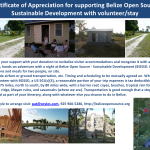
For a birthday fundraiser on Facebook, I invited people to support facilities upgrades for our visitors accommodations. Donations will be recognized with a one night stay at the at the site. As one can see from the image, improvements are in order. … [Read more...] about Birthday Fundraiser for Belize Open Source